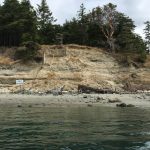
 Problem: Eroding bluff may threaten power cables

In 2017 Coastal Geologic Services performed a geologic and coastal processes evaluation for a large feeder bluff on the southern end of Blakely Island. Buried power cables installed many years prior were the subject of concern at this site. CGS performed a site reconnaissance and historical shore change assessment to determine if the buried cable landing was at risk of soon being exposed to waves and drift logs on the beach.
The CGS Solution

CGS completed historical shore change mapping and current erosion rate work to project bluff change near the cable landing. This allows OPALCO to plan for future risks, and simple monitoring methods recommended by CGS will assist OPALCO with preparedness. CGS also cited regional projections for sea level rise to further inform management recommendations so as to ensure that the owners have the necessary information to effectively manage their cable crossing.
Results
With augmented knowledge of natural bluff processes, and consistent monitoring in place, the utility company is more prepared to take informed action to manage their cable landing.
More Regional Assessment Case Studies
Click on each image below to learn more about CGS regional assessment projects.
 |  |  |